Other Gallery Entries
DEWS – Distant Early Warning System for Tsunamis: A Multi-hazard Approach
DEWS (Distant Early Warning System) project, funded under the 6th Framework Programme of the European Union, has the objective to create a new generation of interoperable early warning systems. The principal focus of the project is on tsunamis caused by earthquakes but other geological paradigms are going to follow, e.g. volcanic eruptions or landslides.
The project consortium agreed to adopt free and open source software wherever possible. In this vein the DEWS Command and Control User Interface is based on Eclipse RCP, uDig and GeoTools.
Motivation
The DEWS (Distant Early Warning System) project, funded under the 6th Framework Programme of the European Union, has the objective to create a new generation of interoperable early warning systems based on an open sensor platform. This platform integrates OGC SWE compliant sensor systems for the rapid detection of earthquakes, for the monitoring of sea level, ocean floor events, and ground displacements. Based on the upstream information flow DEWS focuses on the improvement of downstream capacities of warning centres especially by improving information logistics for effective and targeted warning message aggregation for a multilingual environment. Multiple telecommunication channels will be used for the dissemination of warning messages.

Approach
Wherever possible, existing standards as well as free and open source software have been integrated. The Command and Control User Interface (CCUI), a rich client application based on Eclipse RCP (Rich Client Platform) and the open source GIS uDig , integrates various OGC services. Using WMS (Web Map Service) and WFS (Web Feature Service) spatial data are utilized to depict the situation picture and to integrate a simulation system via WPS (Web Processing Service) to identify affected areas. Warning messages are compiled and transmitted in the OASIS CAP (Common Alerting Protocol) standard together with addressing information defined via EDXL-DE (Emergency Data Exchange Language – Distribution Element). Internal interfaces are realized with SOAP web services.
Future
Based on results of GITEWS (German Indonesian Tsunami Early Warning System) the DEWS approach provides an implementation for tsunami early warning systems. But in future also a multi-hazard functionality is conceivable. The specific software architecture of DEWS makes it possible to dock varying sensors to the system and to extend the CCUI with hazard specific functionality.
Utilization of uDig and GeoTools
Within the CCUI, perspectives show all functionality associated with a comprehensive task fulfilled from the operator on duty. Each perspective has a default layout with a map and additional views appropriate for the respective task. Five perspectives of the CCUI support the operator in his duty to manage a tsunami threat. Three of them make use of uDig and GeoTools:
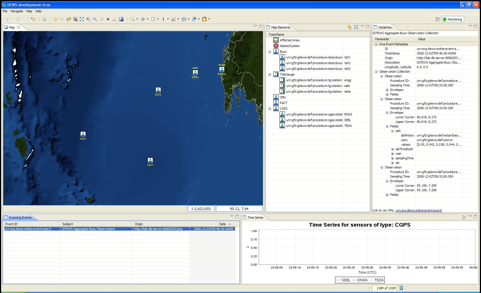
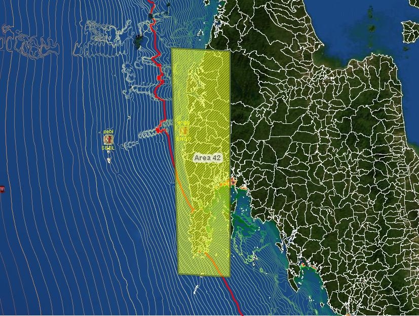
The Monitoring Perspective provides a survey of a specific area and contributes an overall situation picture to the operator with geo-spatial information displayed in a central map, and additional details contained in multiple views surrounding the map. The GIS functionality is provided by uDig and realizes the map showing administrative areas, sensor positions, affected areas, wave front, epicenter, etc.
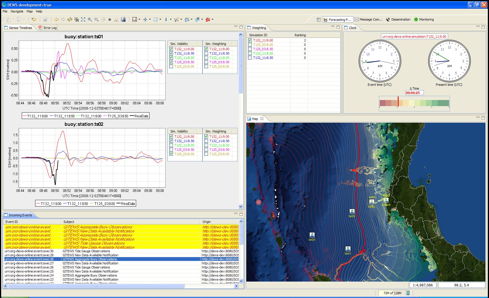
The Forecasting Perspective extends the CCUI to support the operator in analyzing the different probable forecasts provided by the simulation system. The sensor time series diagrams (forecasts) are generated shapefiles of the simulation system, processed with GeoTools and displayed with JFreeChart. Forecasts are additionally displayed in the map with coloured isochrones by programmatically added SLD (Styled Layer Description) / SE (Symbology Encoding). The outlined isochrones represent the tsunami wave propagation in time between the earthquake location and the impact at the coast. The predicted real-time wave position is highlighted in red and continously updated.

The Message Composition Perspective supports the operator in its task to prepare, to send and to observe the initiated warning dissemination. The map depicts the specific geographic region with the information provided by the other perspectives. Additionally affected areas are displayed in the map. According to the selected forecast they are automatically calculated with GeoTools or manually selected with uDig functionality.
About uDig
uDig is an open source desktop GIS application framework, distributed under dual EPL and BSD license.
uDig provides:
- An out-of-the-box application, with the ability to view, edit and print files, database (Oracle, SDE, PostGIS) and Web Feature Servers (WFS).
- An industry-standard extension framework (RCP) for adding new functionality to the application.
- A rich toolkit of Java functionality, ready for developers to build on.
- Native support for Windows, Mac OS/X and Linux.
uDig is developed by a world-wide community of contributors, with an open process and transparent decision making.
About Refractions
Refractions Research is a consulting and systems integration company, with industry-leading exertise in enterprise geospatial applications. Refractions initiated and now hosts the uDig and, PostGIS projects, and continues to provide core development, training and consulting on the projects.