User-friendly Desktop Internet GIS (uDig) for OpenGIS Spatial Data Infrastructures
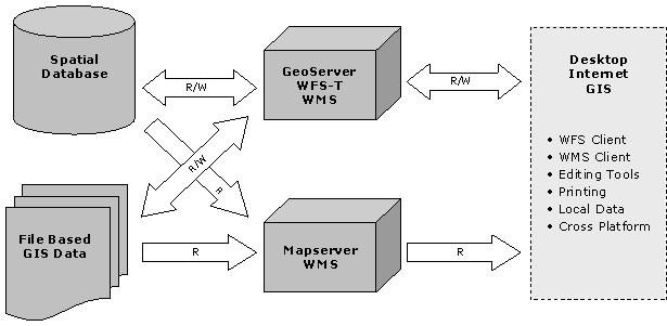
The Canadian Geospatial Data Infrastructure is a distributed system maintained by many levels of government, private companies, and non-governmental organizations. The CGDI systems provide services for viewing, retrieving and analyzing spatial information -- information that is generally represented on maps. Open-source components are a critical part of the CGDI vision, because they allow organizations to deploy infrastructure widely, in a distributed fashion, without incurring multiple licensing fees. Open-source components are also the most tractable for fast support of new OpenGIS interoperability standards. There were already many different pieces of open-source software that implement OpenGIS server standards: Mapserver implemented WMS, GeoServer implemented WMS and WFS-T, PostGIS implemented SFSQL, DeeGree implemented WMS and WFS, and so on. However, there was not a single piece of desktop software capable of binding information from all these servers together into a unified desktop view. uDig is the open-source application which brings CGDI data sources to the desktop, and integrates them with local data sources for standard business processes - data viewing, data editing, and data printing.
Interactive desktop access was the missing application in open-source OpenGIS standards-based spatial infrastructures -- uDig fills the gap.. |