Arc Tool
 Creates a linestring approximating an arc given three control points (initial point, axis,
and end point).
The Arc Tool allows to create a Feature whose Geometry is a linear approximation of an arc of circumference, by specifying three points which define two consecutive arc chords.
Behaviour
The Arc Tool is a Feature creation tool and operates over the currently selected Layer, thus the currently selected Layer must allow LineString geometries, whether its feature types specifies them to be LineString or MultiLineString. When the Arc Tool proceeds to create the new Feature, it does not commits it, allowing the user to undo the operation, set the Feature attribute values or commit the changes as usual in uDig.
Visual consistency
In order to preserve visual consistency, and thus be consistent with what the user is doing, the geometry created by the Arc Tool will be first created in the Map’s CRS, and then projected to the backend CRS for storage. This allows the user to create the arc in the desired CRS by setting the Map CRS to a meaningful one for his purposes. A side effect will be, that if the data and Map CRS differ, the geometry will be an arc of circumference in the Map CRS but probably not in the data CRS.
Usage
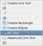
As shown in Figure 1, to start using the Arc Tool you have to first select it from the drop down menu in the uDig’s editting tools Toolbar.

Figure 1 select *Arc Tool*
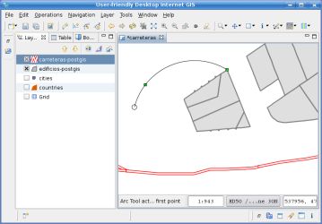
Once the tool is selected, you need to specify three points that defines the arc. For any of the three points you can use the snap area, if activated, in order to snap to a vertex from another Feature. Figure 2 shows the feedback shown when only two points have been specified. You’ll see the resulting arc at any moment until the third point is specified.

Figure 2 specify control points
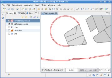
With a single click, specify the third point and the Feature with an arc geometry will be created as shown in Figure 3. The resulting geometry will be a LineString approximation of the actual arc.

Figure 3 arc created after specifying third point