 org.geotools.referencing.wkt.Formattable
org.geotools.referencing.datum.BursaWolfParameters
org.geotools.referencing.wkt.Formattable
org.geotools.referencing.datum.BursaWolfParameters
|
|||||||||||
| PREV CLASS NEXT CLASS | FRAMES NO FRAMES | ||||||||||
| SUMMARY: NESTED | FIELD | CONSTR | METHOD | DETAIL: FIELD | CONSTR | METHOD | ||||||||||
java.lang.Object
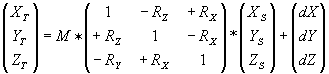
Parameters for a geographic transformation between two datum. The Bursa Wolf parameters should be applied to geocentric coordinates, where the X axis points towards the Greenwich Prime Meridian, the Y axis points East, and the Z axis points North. The "Bursa-Wolf" formula is expressed in matrix form with 7 parameters:
| Field Summary | |
double |
dx
Bursa Wolf shift in meters. |
double |
dy
Bursa Wolf shift in meters. |
double |
dz
Bursa Wolf shift in meters. |
double |
ex
Bursa Wolf rotation in arc seconds. |
double |
ey
Bursa Wolf rotation in arc seconds. |
double |
ez
Bursa Wolf rotation in arc seconds. |
double |
ppm
Bursa Wolf scaling in parts per million. |
org.opengis.referencing.datum.GeodeticDatum |
targetDatum
The target datum for this parameters. |
| Constructor Summary | |
BursaWolfParameters(org.opengis.referencing.datum.GeodeticDatum target)
Constructs a transformation info with all parameters set to 0. |
|
| Method Summary | |
java.lang.Object |
clone()
Returns a copy of this object. |
boolean |
equals(java.lang.Object object)
Compares the specified object with this object for equality. |
protected java.lang.String |
formatWKT(Formatter formatter)
Format the inner part of a Well Known Text (WKT) element. |
XMatrix |
getAffineTransform()
Returns an affine transform that can be used to define this Bursa Wolf transformation. |
int |
hashCode()
Returns a hash value for this object. |
boolean |
isIdentity()
Returns if this Bursa Wolf parameters performs no operation. |
boolean |
isTranslation()
Returns if this Bursa Wolf parameters contains only translation terms. |
void |
setAffineTransform(org.opengis.referencing.operation.Matrix matrix,
                   double eps)
Sets transformation info from the specified matrix, which must be affine. |
| Methods inherited from class org.geotools.referencing.wkt.Formattable |
toString, toWKT, toWKT, toWKT |
| Methods inherited from class java.lang.Object |
finalize, getClass, notify, notifyAll, wait, wait, wait |
| Field Detail |
public double dx
public double dy
public double dz
public double ex
public double ey
public double ez
public double ppm
public final org.opengis.referencing.datum.GeodeticDatum targetDatum
| Constructor Detail |
public BursaWolfParameters(org.opengis.referencing.datum.GeodeticDatum target)
target - The target datum for this parameters.| Method Detail |
public boolean isIdentity()
public boolean isTranslation()
public XMatrix getAffineTransform()
This affine transform can be applied on geocentric coordinates.S = 1 +ppm/1000000 [ X? ] [ S -ez*S +ey*Sdx] [ X ] [ Y? ] = [ +ez*S S -ex*Sdy] [ Y } [ Z? ] [ -ey*S +ex*S Sdz] [ Z ] [ 1 ] [ 0 0 0 1 ] [ 1 ]
public void setAffineTransform(org.opengis.referencing.operation.Matrix matrix,
                               double eps)
                        throws java.lang.IllegalArgumentException
matrix - The matrix to fit as a Bursa-Wolf construct.eps - The tolerance error for the antisymmetric matrix test. Should be a small
number like .
java.lang.IllegalArgumentException - if the specified matrix doesn't meet the conditions.public int hashCode()
public java.lang.Object clone()
clone in interface org.opengis.util.Cloneablepublic boolean equals(java.lang.Object object)
protected java.lang.String formatWKT(Formatter formatter)
TOWGS84[dx, dy, dz,
 ex, ey, ez, ppm]
.
formatWKT in class Formattableformatter - The formatter to use.
Formattable.toWKT(),
Formattable.toString()
|
|||||||||||
| PREV CLASS NEXT CLASS | FRAMES NO FRAMES | ||||||||||
| SUMMARY: NESTED | FIELD | CONSTR | METHOD | DETAIL: FIELD | CONSTR | METHOD | ||||||||||